
My friend John Robison has been going through old documents and newspaper clippings that have been gathering dust in the First Methodist Church in Kennett, Missouri (our home town). Below are two accounts of the early days of Kennett. This first one appears to have been written in 1976. Original typescript (page 1, page 2) The second account was written in 1966 Typescript (page 1, page 2)
A Thumb-Nail Sketch of Kennett and Vicinity
— Patti and Charles Redmond
Kennett may not have a “great” history in the sense of “great happenings”. but our history is very interesting, and great things have taken place within the area.
Geologists tell us that this entire area (as far north as almost to Cape Girardeau) once lay in what would have been the Gulf of Mexico, and this was millions of years ago. They say that during the “lee-ages” great flows from the northern plains created the Missouri and the Mississippi Rivers, and that these great flows brought rocks, earth, silt, and debris southward and deposited them in the “Gulf”, building up that area and extending it to what we now know as the Gulf Of Mexico, They also say that the Ohio River existed long before the Mississippi, and that the Ohio then ran to the Gulf, and that the Mississippi then captured the Ohio, took it over, and became generally as we know it now. They also say that as the Mississippi River was developing it wandered back and forth over this part of the land covering the many other streams that existed. They say that though the influence of the Mississippi changed the locations of other streams, our St. Francis River remains today just about in the same location as it originally did, resisting all efforts t change its location. As the flows and floods continued this part of our land was covered by the rich soil deposits from the north, making it the richest farming land in the country. The great “New Madrid” earthquake also had great influence upon our ares, and changed our topography to a great extent. Even today, in some parts of the County, the “sand-blows” are still visible where the hot gases escaped and “burned” the soil; and it was this earthquake that created Reelfoot lake (Tenn.), Big Lake (at the south end of the County) and the St. Francis River “Sunk-Lands” (which start just below Cardwell and extend southward many miles). area was a maze of swamps and lowlands even up into the early 1900’s and about that time the drainage systems and the levee systems were started to drain the lands and to protect from floods.
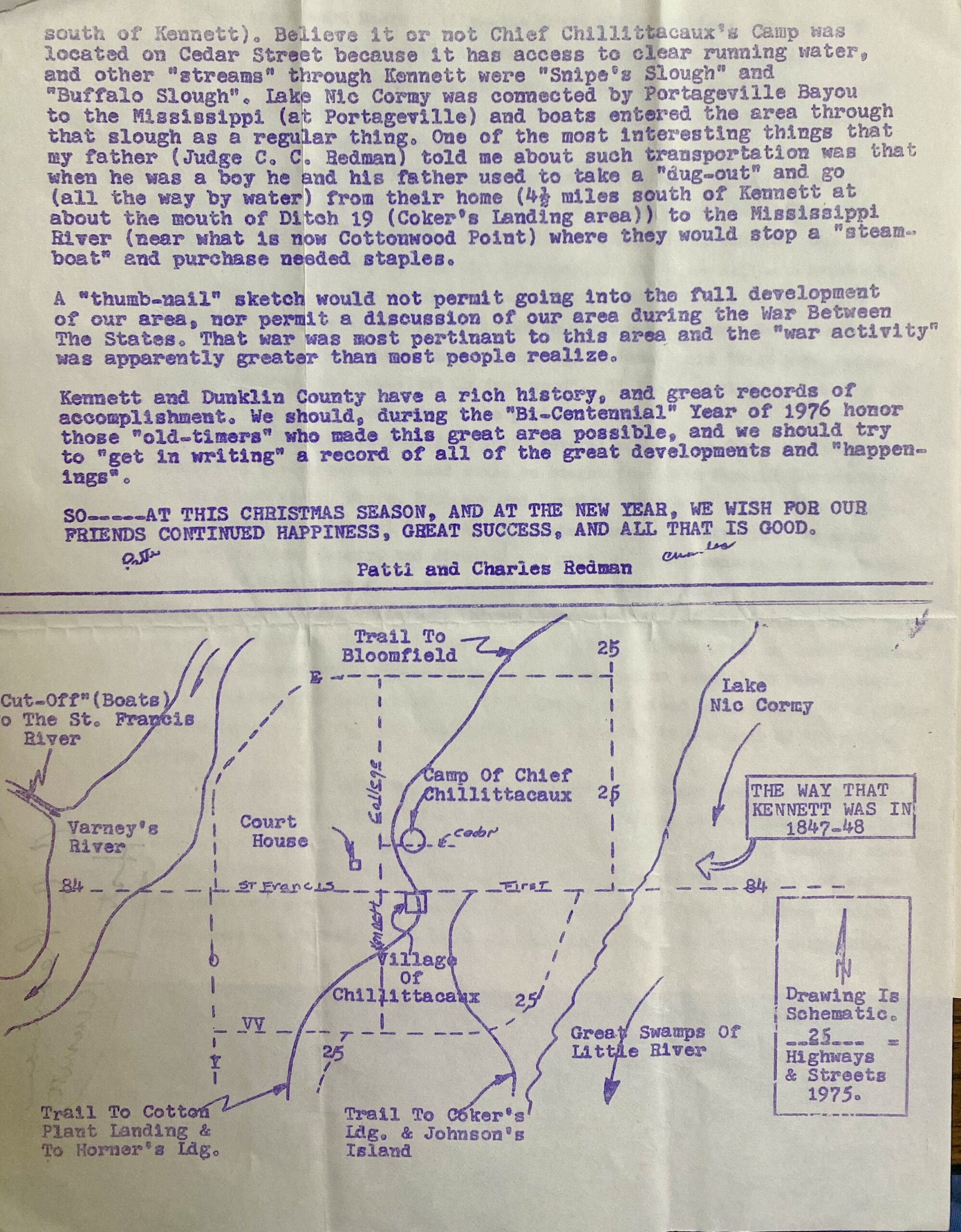
Kennett was originally an Indian Village and it was called the Village of Chillittacaux after Chief Chillittacaux. At the time of the Government Land Surveys (1847-48) it is said that Chief Chillittacaux’s Camp was located pretty well astride of what is now Cedar Street, just east of College Ave. It is said that as the Village developed the chief moved his camp to a point just north of what we know as Friendship –on Indian Camp Slough (now Chillittacaux Ditch) –and that the camp remained there until the departure from this area of the Indians. ( My father, who would have been 106 years old now, told me of seeing Indians, when he was just a small boy going to Bloomfield with his father (by ox team and wagon) to sell cotton, at the site above Friendship. The name of our town was later changed to Butler, and then it was discovered that there was already a Butler, Missouri and so it was changed again to Kennett.
In the beginning Kennett was bounded on the east by the Great Swamps of Little River and by Lake Nic Cormy; was bounded on the west by the swamps of Varney’s River which connected to the St. Francis River (just north of the bridge on Rte. 84) by what was known as the “Cut-Off” and through which “cut-off” boats could reach to about where Fray’s Mill is now located. (This writer saw the last “steamboat” on the St. Francis River west of Kennett–when he was just a small boy). These runs, sloughs, and rivers were the means of transportation, not only for the Indians but also for all others. Steamboats came up Little River and Horner’s Landing (Hornersville) was an important stop; when water permitted the boats came on up to Cotton Plant, Hlckory Lauding, and Coker’s Landing (just south of Kennett). Believe it or not Chief Chillittacaux’s Camp was Located on Cedar Street because it has access to clear running water, and other “streams” through Kennett were “Snipe’s Slough” and “Buffalo Slough”. Lake Nic Cormy was connected by Portageville Bayou to the Mississippi (at Portageville) and boats entered the area through chat slough as a regular thing. One of the most interesting things chat my father (Judge C. C. Redman) told me about such transportation was that when he was a boy he and his father used to take a “dug-out” and go (all the way by water) from their home (4 1/2 miles south of Kennett at about the mouth of Ditch 19 (Coker’s Landing area) to the Mississippi River (near what is now Cottonwood Point) where they would stop a “steamboat* and purchase needed staples.
A “thumb-nail” sketch would not permit going into the full development of our area, nor permit a discussion of our area during the War Between The States. That war was most pertinent to this area and the “war activity” was apparently greater than most people realize.
Kennett and Dunklin County have a rich history, and great records of accomplishment. We should, during the “Bi-Centennial” Year of 1776 honor those “old-timers who made this great area possible, and we should try to “get in writing” a record of all of the great developments and “happenings.”
SO—-AT THIS CHRISTMAS SEASON, AND AT THE NEW YEAR, WE WISH FOR OUR FRIENDS CONTINUED HAPPINESS, GREAT SUCCESS, AND ALL THAT IS GOOD.
— Patti and Charles Redmond
The Start of Kennett
— By C. R. Talbert (1966)
The first settlement at Kennett was made by a small tribe of Shawnee Indians who came down from Ohio about 1800. They fished and hunted, and grew corn and vegetables.
When the Howard Moore family–the first white settlers came in 1829 they found some fifty log huts located thinly over what is now the old part of town. Chilletecaux was the name of the chief, and the village had the same name. The chief’s cabin and a few others stood near the present home of Mrs. Ben Cash on Cedar Street.
In 1830 congress passed a law directing that all Indians living in the southern states must move to Oklahoma-to the eastern part, later called the Indian Territory. The chief of each tribe, or his representative, was taken there to select a tract of land for his people. This was called a Reservation. The Shawnees were moved from here about 1834. All had to go except squaws who had married white men, of which there were a few. Chilletecaux sold his cabin to Mr. Moore, and is supposed to have said “Heap good house. All logs cypress but one–that is just wood”. It probably had dirt floor, as did the cabins of the white settlers of the period.
Within the next four or five years several more white families came, and cleared up fields nearby. Land could be bought from the Federal Government for $1.25 an acre. Moore, Holloway and Langdon were some of the first names.
In 1845 the Missouri Legislature Created Dunklin County From the south part of Stoddard County, and directed , that the seat of government should be at the village of Chilletecaux. Some county officers were elected, as provided, in 1846 and some taxes collected. Hiram Langdon was one of the first county judges. He led in building the first court house in 1847. It was built of hewed cypress logs and floored with rip-sawed planks. There was no sawmill to make lumber. It was roofed with split boards called shakes, and stood where Dr. Peck’s office is now located. A log jail was built some distance to the west of the court house.
The first post office was set up December 8, 1845 and named “Dunklin Court-house” by the postal department. There was no building at the time. The citizens got the name changed to Chilletecaux on April 24, 1846. This hard name was used for about 15 years. The people then asked Washington to name the place something easier to spell, and sent in the name “Butler” as a suggestion. The Department replied that there was already a Butler in Missouri and asked for another suggestion. They submitted the name Kennett, and it was approved in 1860. The name was for Luther M. Kennett who died about that time. He had been mayor of St. Louis in 1851 and 1852. He was a popular person and, as mayor of the only real city in the state, was a very important person. St. Louis had a population of 77,000 in 1850 according to Campbell’s Gazetteer, published in 1874.
Dunklin County was named for Daniel Dunklin who was Governor of Missouri from 1824 to 28. He died the year the county was created, as his home near Potosi.
The Civil War began in 1861, and mail service was practically nil for several years. The log courthouse was burned during the war and many of the county records lost. At the beginning of the war Kennett had one grocery, three general stores, a hotel and several saloons. The population was about 200. Clarkton had 350 people and was the county metropolis. Hornersville had about the same population as Kennett.
In 1870 a new courthouse was started on the ashes of the old one. The log jail was still there. There was then a saw mill to make regular lumber, so this second building was a frame and plank affair, and two stories high. It burned on April 7, 1874. The county then rented for 18 years a large plank store building that stood on the square about where Everett Farmer’s Shoe Store now stands. The building also doubled for a church–Methodist, Baptist and Presbyterian–at staggered times.
A brick courthouse was built in the center of the square in 1892, at a cost of $15,000. It served the county for 45 years, when being about worn out, it was pulled down in 1937. The present splendid building was built on the same spot in 1938.
Among the families here 90 to 100 years ago, and still represented by name in addition to these already named, are Shelton, Bragg, Ledbetter, Jones, Redman, McHaney, Tatum and Dunmire and probably a few more.
When I came to Kennett in August 1922 there were three thousand people here. They were paving the square. The only concrete street (or road) in the county was Washington Street which had been paved in 1916.
History buffs might also enjoy A Tribute to a Country Store (Gobler Mercantile Company: 1937-1956) was written by Virginia B. Branch